Utility Mapping: How LiDAR Technology is Transforming Utility Infrastructure Surveys
Published on 3/7/2025 by HR Utilities
At HR Utilities, we are committed to staying at the forefront of technological innovation to provide the most accurate and efficient solutions for our clients. With the recent acquisition of cutting-edge LiDAR drone equipment, we are proud to expand our capabilities in underground utility mapping, setting a new standard for precision, efficiency, and safety. If you need end‑to‑end delivery, our utility mapping solutions convert field data into CAD/GIS plans. For comprehensive underground mapping services across Melbourne and Victoria, contact our expert team today.
What is LiDAR Technology?
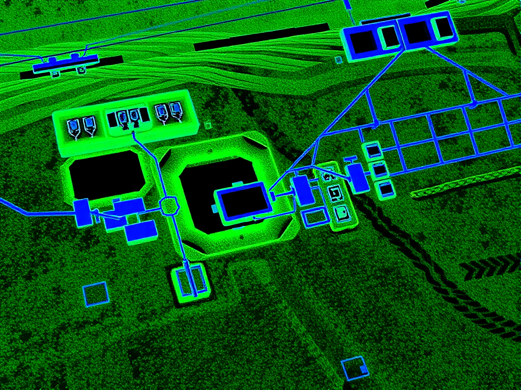
LiDAR, short for Light Detection and Ranging, is a remote sensing technology that uses laser pulses to measure distances. By emitting laser beams and capturing the time it takes for the pulses to return after hitting an object, LiDAR generates highly detailed three-dimensional maps. When paired with drones, this technology becomes a game-changer for utility mapping, offering unprecedented accuracy and speed.
The Impact of LiDAR on Underground Utility Mapping
Traditional methods of locating underground utilities often involve labor-intensive processes that can lead to inaccuracies and inefficiencies. LiDAR has transformed this landscape by providing:
- Maximum Accuracy: LiDAR captures precise spatial data, significantly reducing errors in identifying the location, depth, and type of underground utilities
- Efficiency: The ability to rapidly collect data over extensive areas streamlines workflows, saving time and resources compared to conventional methods
- Enhanced Asset Management: By offering a three-dimensional view of subsurface utilities and their spatial relationships, LiDAR enables better planning and decision-making
- Improved Safety: Accurate mapping minimizes the risk of accidental damage during construction or excavation, ensuring the safety of workers and the community
For locating inputs that complement LiDAR deliverables, learn more about our utility locating services.
Benefits of Using LiDAR Drones
The integration of drones with LiDAR technology amplifies its advantages. Drones provide a bird’s-eye view, enabling quick data collection across large or hard-to-reach areas. This combination is particularly beneficial in urban environments where underground utilities are dense and complex.
Key benefits include:
- Rapid Deployment: Drone-mounted LiDAR systems can be deployed quickly, reducing project timelines
- Accessibility: Drones can navigate challenging terrains or congested areas where traditional equipment might struggle
- Cost-Effectiveness: Faster data collection translates into reduced labor costs and project expenses
Integration Process at HR Utilities
Implementing LiDAR technology into our operations involves a systematic approach to ensure accuracy and reliability:
- Data Collection: Our new LiDAR drones capture high-resolution data from project sites
- Preprocessing: Raw data is cleaned and prepared for analysis
- GIS Integration: Data is aligned with existing utility records using Geographic Information Systems (GIS) or CAD software for comprehensive visualization
- Validation: Cross-referencing with known records ensures accuracy before finalizing utility maps
This meticulous process allows us to deliver precise results tailored to each project’s needs.
A Safer, Smarter Future
The adoption of LiDAR technology underscores our commitment to innovation and excellence in underground utility mapping. By leveraging this advanced tool, we not only enhance the accuracy and efficiency of our services but also contribute to safer excavation practices and better infrastructure management.
At HR Utilities, we believe that investing in state-of-the-art technologies like LiDAR is an investment in our clients’ success. Whether you’re planning a construction project or managing existing infrastructure, our expanded offerings are designed to meet your needs with precision and reliability.
Related services:
- Subsurface Utility Mapping Services — AS5488-compliant mapping in CAD, GIS, and BIM
- Surface & Trench Mapping — UAV and handheld capture for combined site models
- Utility Data Deliverables — CAD, GIS, BIM-Ready Plans — Survey-grade data your engineers can use
Ready to experience the precision of LiDAR technology in your next project? Contact HR Utilities to learn more about our advanced mapping services or book underground service location in Melbourne.
Stay Connected: